Courtesy of Tomáš Beňák, Miroslav Havran, Tomáš Hovorka, Jozef Joppa, Mayor Iveta Dzubriaková Kundrátová, Peter Kundrát, Marek Olejar, Steven Osifchin, Miro Polča, Ďuro Sarvaš, Michael Senko
Thank you to Mayor Iveta Kundrátová
Transcribed by Steven M. Osifchin
Courtesy of Ronald Sommers
(Partial) Compiled by Steven M. Osifchin
Courtesy of Ronald Sommers
(Coming Soon)
The center of the village is 600 meters above the sea level. Surrounding area is between 550-884 meters above the sea level. Matysová is situated in the Lubovnianske hills in the valley of the creek Lipnik. Village territory is situated on the geological formation of Maguras rocks and it is pretty well rocky. Most of the forests are cleared and some forest remains on the outskirts. On the western side there is a cliff Marmon, where they used to mine the reddish limestone that was very similar to marble. In the vicinity of Marmon there are numerous small caves. Soils that prevail are brown forest soils.
The village was incorporated under buying law in the second half or the 14th century, first mentioned in 1408. It belonged to the landlords of Plavec. In 1787 it had 58 dwellings and 395 inhabitants, in 1828 68 houses and 505 inhabitants. They were farmers, they had sheep, burning lime and linen making. Their professions didn't change much after 1918. Private farmers are working soil. Part of the inhabitants are working in Stara Lubovna, Podolinec and Maly Lipnik.
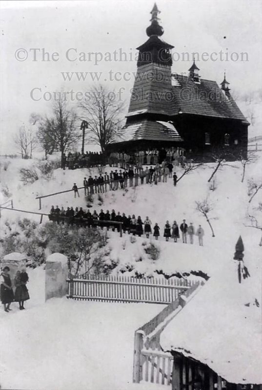
Wooden Greek Catholic Church from 1833 is now in Stara Lubovna skanzen. Photo from 1924.
Photo Courtesy of Slavo Gladis.
Different names of the village over time:
1408 Mathezhaw, 1773 Matissowa, 1786 Matischowa, 1920 Matis`ova, 1927 Matysová; Hungarian: Matiszova, Mate; Matysovsky; Matysovcan, -ka. Saris County; district Srtara Lubovna, region Presov until 1960; district Presov, Eastern Slovakia Region, Region Presov 1996. The names of the parts of surrounding areas: Bydacova, Marmon.
Population in years:
1869-635, 1880-670, 1890-649, 1900-542, 1910-494, 1921-419, 1930-435, 1940-509, 1948-483, 1961-486, 1970-387.
Village Size:
1010 HA is the size of the village. HA is short for Hektar. 1 Hektar is 2.471 acres
Transcribed by Steven M. Osifchin
Courtesy of Ronald Sommers
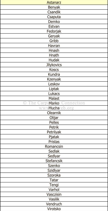
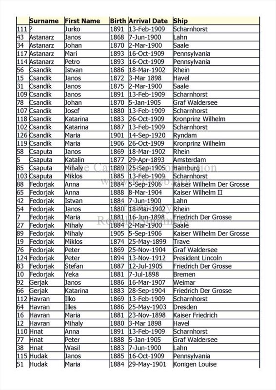
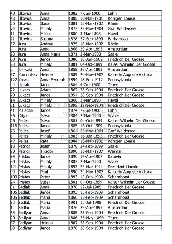
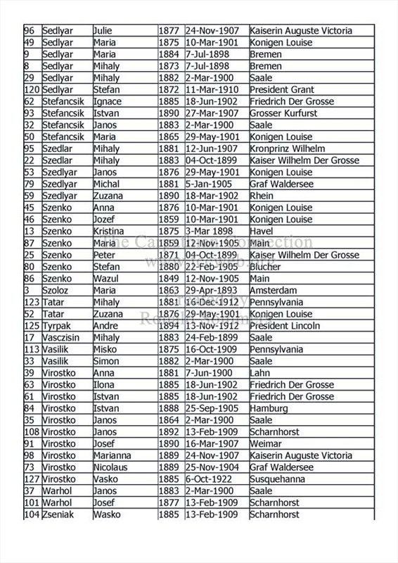
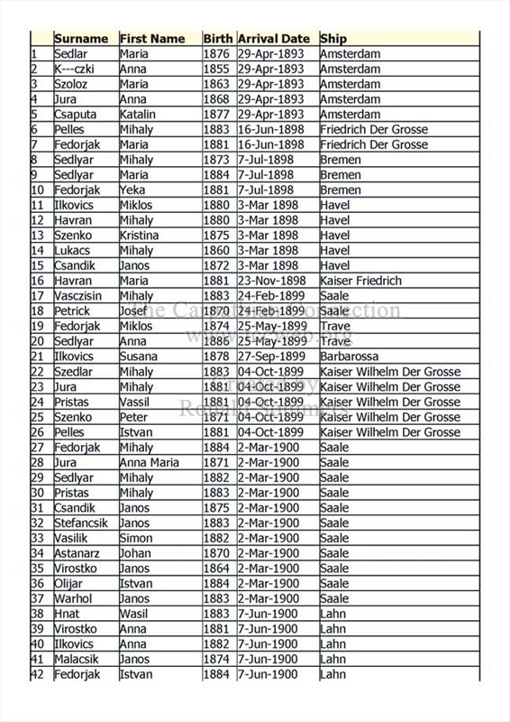
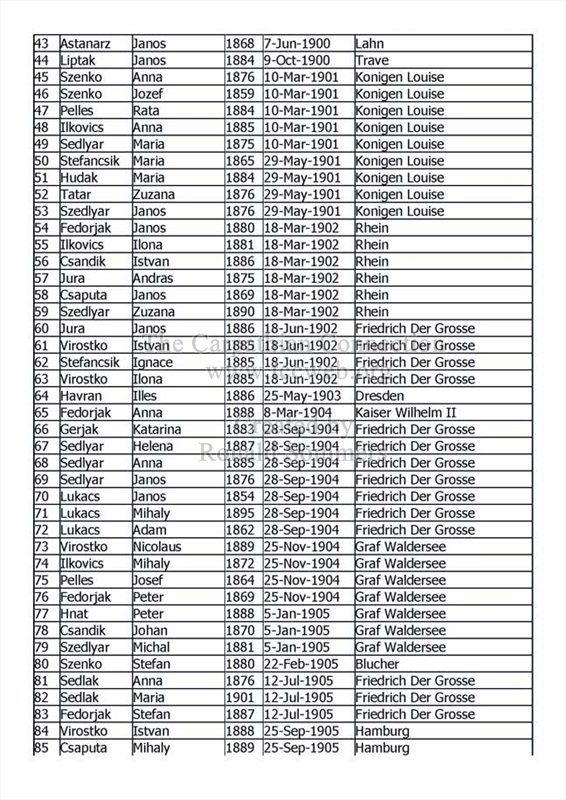
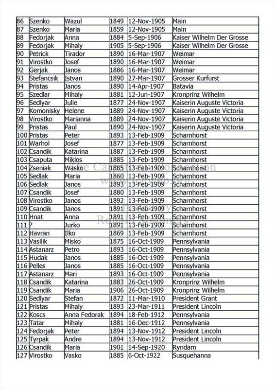
(1) Listing of 121 Matysova immigrants sorted by name; (2) the same listing of Matysova immigrants sorted by date of arrival, including ship name.
(1)
(2)
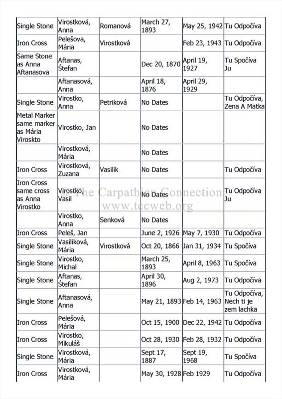
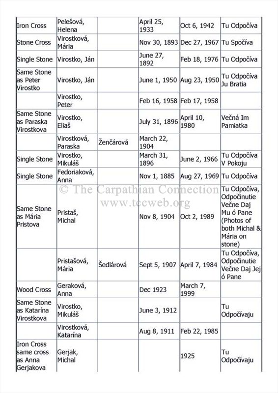
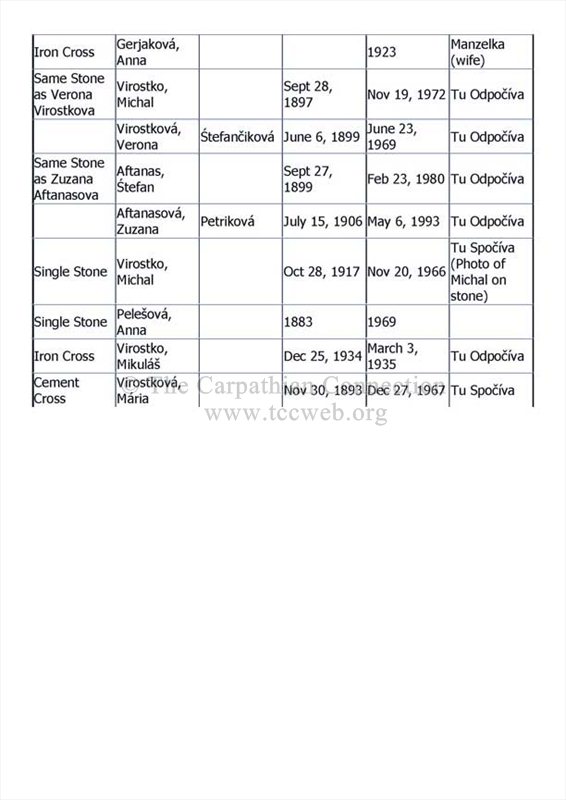
The following is a partial list of the gravestones found in the Matysova Cemetery. This cemetery contains many iron cross markers. This is a rather large cemetery in contrast to the rather small village itself. The cemetery is to the rear of the Greek Catholic Church. This list was compiled by Steven M. Osifchin in May 2004.
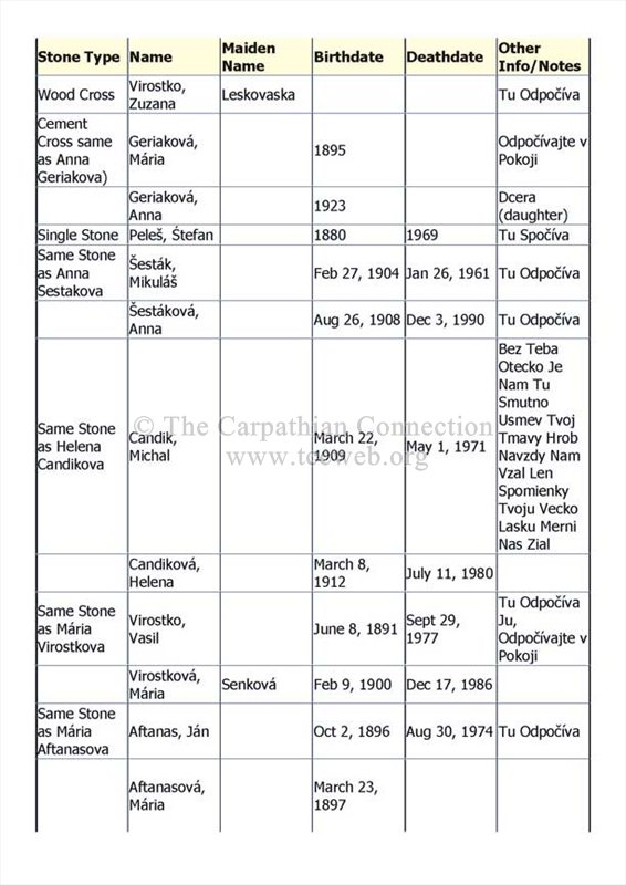
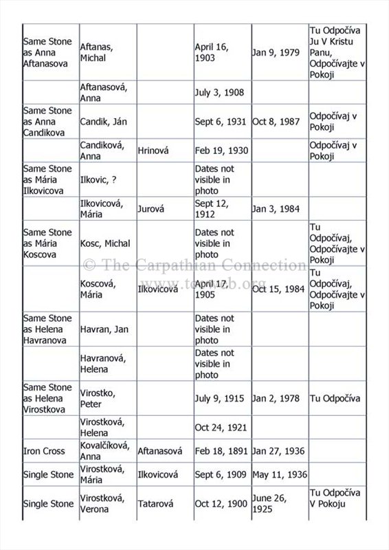
Courtesy of Ronald Sommers
(Coming Soon)